GEOGRAPHIC EXTREMES SOCIETY
AUSTRALIAN RECORDS
Submarine Canyons
The shape, geometry and character of the seabed, collectively referred to as bathymetry, has a major impact on the worth of this Exclusive Economic Zone. In all but a few cases, the continental shelf margin extends outwards from the coast, until sloping away at a markedly steep angle. This normally begins around the 200-metre depth contour line before plunging to the abyssal plain, which around the Australian landmass is approximately 4,000 to 5,000 metres deep.
The bathymetry of Australia’s continental shelf is far from uniform and has a multitude of undersea topographical features. Notable among these are submarine canyons. These submarine canyons, which are essentially eroded incisions on the edges of continental shelves, have lately been an area of increasing interest, along with the riches that abound within the 713 incisions surrounding Australia’s continental shelf.
Most of Australia’s submarine canyons are associated with existing major river sources or ancient palaeorivers draining to the sea. Submarine canyons may look similar to surface canyons, but their development is quite different. The causes of the erosion that forms them are primarily due to turbidity currents of colder, and thereby heavier, freshwater travelling at great speed down the continental shelf slope. Turbidity currents are usually generated by major river flooding events and carry a great deal of cold, densely-laden sediment from rivers. The turbidity currents can attain great speeds as they rush down the continental shelf slope, gouging sediments from the walls before depositing them onto the abyssal plain in erosional fans.
The largest submarine canyons incise the top of the continental shelf and can extend for hundreds of kilometres until eventually merging with the abyssal plain. Only 95 of Australia’s 713 submarine canyons have cut into the top of Australia’s continental shelf in this way, and only a couple of dozen of these fall into the category of mega-canyons, being blessed with a complex topography and a variety of substrates.
Closest proximity of coast to the continental shelf
The closest the continental shelf gets to the Australian coastline is in northern New South Wales around South West Rocks, followed by Bermagui, then Eden both on the New South Wales south coast.
Longest Submarine Canyon
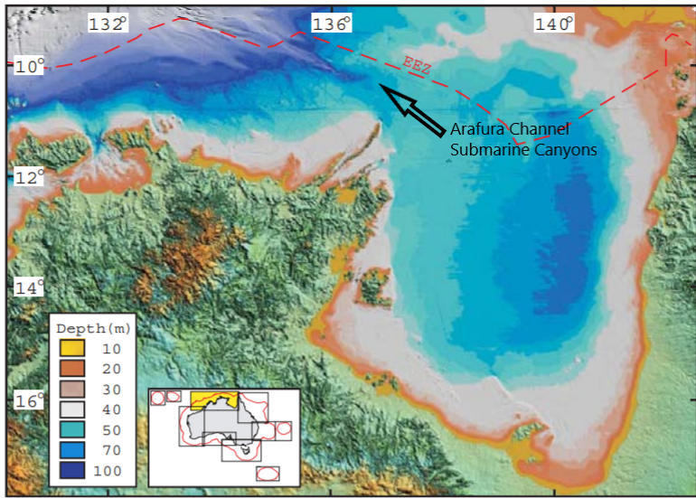
Australia’s longest submarine canyon is in the Arafura Sea and is associated with oceanic crustal fault lines that extend from near Darwin towards the Aru Islands in Indonesia. The longest of these, at 203.7km in length, is at present unnamed but goes by the number 1053. The two next-largest, known as 1052 and 1055, are also in the Arafura Sea adjacent to 1053. All three of these long canyons are associated with what fisherman call the Arafura Channel.

Arafura Channel. Longest Submarine Canyon in Australia. Image: Aust Dept of Environment
Largest Submarine Canyon
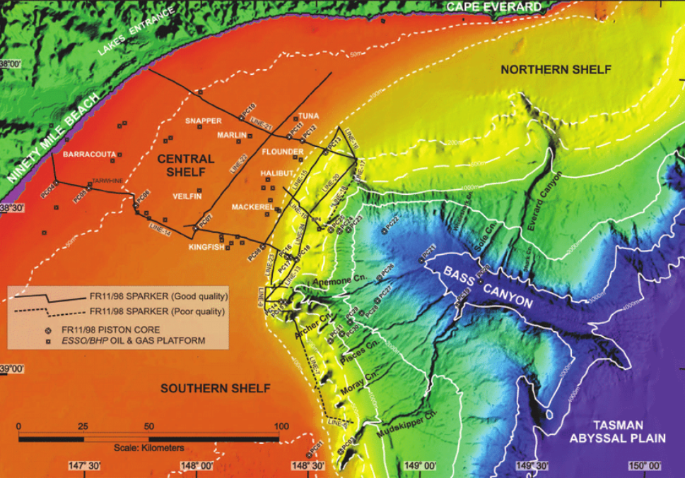
In terms of volume, the largest submarine canyon in Australia,– and one of the world’s giants – is the Bass Canyon, at the eastern entrance to the Bass Strait. The canyon’s volume is a massive 1,345 km3. Comparing this to the 0.5 km3 volume of Sydney Harbour gives you we can get an idea of just how massive this canyon is. During periods of low sea level associated with ice-ages, the south-flowing rivers of Victoria as well as those of the Bassian Plain, under what is today’s Bass Strait, all drained towards the head of the Bass Canyon. This combined river sent its cold snow-melt waters over the shelf, down into the canyon mouth. The Bass Canyon is a giant canyon by world standards, and our next biggest submarine canyons are a third of the size, the Swan Canyon on the edge of the north-west shelf and the Perth Canyon off Perth.

Bass Submarine Canyon. Largest Submarine Canyon in Australia. Image: Wallace 2007
Submarine Canyon Records
GES Record: Largest submarine canyon in the world – Zhemchug Canyon. Bering Sea. Alaska. 5,800km3 (Source: Extreme Science)
GES Record: Largest submarine canyon in Australia – Bass Canyon. Bass Strait. 1,345km3(Source: S Nichol. Geoscience Australia)
GES Record: Longest submarine canyon in Australia – Canyon 1053. Arafura Sea. 203.7km (Source: S Nichol. Geoscience Australia)
The Geographic Extremes Society welcomes any input as to the veracity of these records and we encourage everyone to contribute to these extreme records by contacting us to initiate the discussion
